DEFORESTATION IN UTTARAKHAND
Introduction
Uttarakhand was formed on November 9, 2000. It was carved out of the hilly northwestern corner of Uttar Pradesh. It stretches across an area of 53,485 sq km. Nine of its 13 districts are hilly while the remaining four southern districts are plains. Uttarakhand’s forest area has been spread over 38,000 sq km that constitutes 71% of the total geographical area of the state. Forests in Uttarakhand are endowed with unique and multiple ranges of biodiversity. From the frigid pinnacles of the Himalayan mountains to the damp Alpine clean, sub-Alpine woods, dry calm and soggy mild woodlands to dewy deciduous timberlands, the state possesses diverse biodiversity that in return nurtures a large multiplicity of floral and faunal forms. The state is home to nearly 4048 species of Angiosperms and Gymnosperms belonging to 1198 genera under 192 families. Of these almost 116 species are explicit to Uttarakhand i.e. their geological appropriation is restricted to the limits of the state. 161 types of flora found in Uttarakhand are perceived as rare or undermined under the arrangement of the International Union for Conservation of Nature (IUCN). The state has about 102 species of mammals, 623 species of birds, 124 species of fish, 69 species of reptiles, and 19 species of amphibians. Highly endangered species which are very rare to find nowadays like the Snow Leopard, Musk Deer, Tiger, Asian Elephant, Bharal, Himalayan Monal, Cheer Pheasant, King Cobra, etc. find suitable habitat in the forests of Uttarakhand.
Deforestation
Deforestation is cutting or permanent removal of trees to make space for development projects like dams, reservoirs, hydro-electric power plants, roads etc or this can include clearing the land for farming or brushing, or utilizing the wood for fuel, development or assembling. Backwoods spread over 30% of the Earth's property surface. These forested regions can give food, medication and fuel for in excess of a billion people. Around the world, woodlands give 13.4 million individuals occupations in the timberland area, and another 41 million individuals have occupations identified with backwoods.
According to the data given by Union Ministry of Environment and Forests (MoEF), 44,868 ha of forestland have been diverted to non-forest use in Uttarakhand since 1980. Of this, a limit of 9,500 ha has been redirected for development of streets, trailed by 5,500 ha for hydel ventures and 3,100 ha for transmission lines. The greater part of the woodland preoccupation (68 percent) in the state has occurred after the arrangement of the state in 2000.
The greatest number of advancement extends that necessary woods redirection have been endorsed in Chamoli area. An aggregate of 1,767 ha forestland has been cleared in the locale, second just to Haridwar where the greater part of the woods has been cleared for restoration ventures. Strikingly, the most extreme woods territory that has been cleared for hydel activities, streets and transmission lines is in Chamoli, Tehri Garhwal, Pithoragarh and Dehradun.
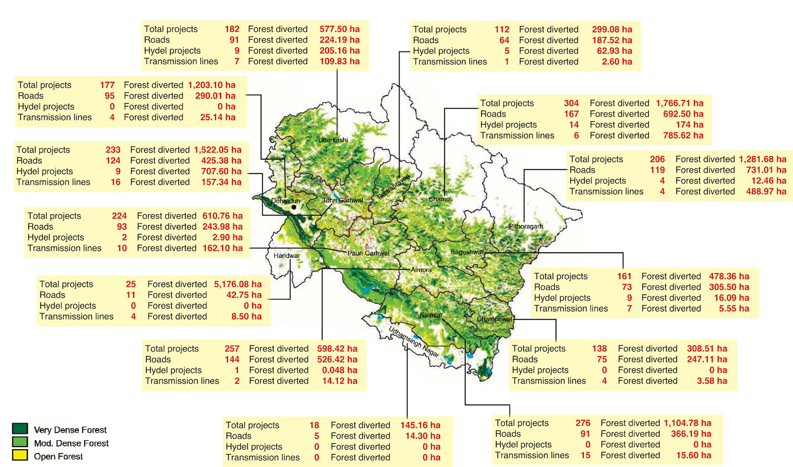
Fig-1 Districts of Uttarakhand showing different development projects and area of forest diverted
")
Fig-2 Graph of Districts of Uttarakhand showing different development projects and area of forest diverted
")
Fig-3 Chart showing different development projects and percentage of area of forest diverted in Uttarakhand
Forest fire is one of the major causes of degradation of forests in the state and is a regular feature every year causing large scale destruction of the forest ecosystems. More than 50% in Himalayan forests in Uttarakhand are prone to high incidence of fire, mostly due to human activities. Thousands hectares of forest every year are burnt into smoke. In 2019 only 2158 incidents of wildfire were recorded in which 3000 ha of forest were lost to smoke. Majority of fires are due to humans and natural causes of fires such as lightning are very less. Causes of forest fires in the western Himalayas of India are due to forest being burnt by villagers for a good growth of grass in the next season; burning of wild grass or undergrowth in the forest in search of game animals, use of fire for collecting forest products like honey, gum etc. and to destroy stumps of illegal felling activities. Accidental fires are also due to carelessness of humans, such as throwing of burning match sticks or cigarettes and spread of fire from picnic sites and other recreational areas.
The Forest Department uses forests more as a source of raw materials for industries and as a revenue generating machine for the state. Large tracts of broad-leaved banj (oak) or oak and burans (rhododendron) forests were replaced by chir pine plantations. Pine is the major source of timber and resin which is used in industries. But it does not help the forest to provide the same level and quality of environmental services.
 vs. Year")
Fig-4 Chart showing area of forest affected by forest fires
Effects of deforestation
Uttarakhand is endowed with a unique and diverse range of biodiversity. From the snowbound pinnacles of the Himalayas to the clammy Alpine scour, sub Alpine woods, dry – mild and damp calm backwoods to wet deciduous woodlands, the state has a wide biodiversity that consequently supports a huge variety of flower and faunal structures. Due to deforestation every year Uttarakhand is losing its unique range of biodiversity and the number of endemic species is decreasing every year.
With deforestation, there is a huge loss of topsoil and the moisture in the atmosphere is decreasing resulting in soil erosion and desertification. Which is affecting the overall efficiency of soil and the production of crops is decreasing. Having very low fertile soil and poor irrigation facilities, most families in hilly areas are unable to grow sufficient crops to meet the annual household requirements. Therefore many farming families have given up farming and are migrating to cities.
Deforestation also leads to an increase in greenhouse effect and further leads to global warming and rise in temperature. Which is the major cause of floods, landslides and climate change.
Climate change has emerged as a critical issue in the state. Uncertainty of rain and snow appears to be increasing. Rain in the winter season has almost disappeared and the inner Himalayan peaks have much less snow as compared to earlier. The frequency of extreme weather events seems to be increasing. Many places in Uttarakhand saw drought during the year 2009 but 2010 saw heavy rains and landslides in the Kumaon region during the monsoon season.
Massive floods and landslides in June 2013 led to Uttarakhand’s worst disaster in living memory in which more than 2000 houses were wiped out, dead and missing people’s toll were over 6,000 people and has cost Uttarakhand Rs 50,000 crore in infrastructural loss.
How to stop
The Uttaranchal government is already working on forming a ‘Van Sena’ (forest army) at the state, district, and block and village level for the protection of the forests. The main objective of this army would be to collect information related to preservation of the forests, keeping an eye on illegal activities, stopping human activities that are harmful for the forests and communicating it to the forest department.
The government’s decision to create ‘green belts’ for forest protection is also a welcome step as under this scheme plans are afoot to regenerate forests with the varieties of flora.
We need alternate source of energy for decreasing our dependence on Hydroelectric power plants for electricity and for that we should use solar energy more for our daily household electricity requirements and Uttarakhand government has also launched Mukhyamantri Saur Swarojgar Yojna in which the government will help people to setup 25kW solar energy unit in their field which will generate approximately 38000 unit of electricity yearly and government will buy that.
Families in rural areas of Uttarakhand are still dependent on wood for cooking their food. Providing them LPG connections would also be beneficial and will decrease the deforestation.
Strengthening decentralized forest governance institutions like the Van Panchayats, Mahila Mandal Dals better measures to contain forest fires, biodiversity conservation. Chandi Prasad Bhatt, during his tenure as a member of the National Forest Commission had proposed the concept of a Gram Van (village forest). He also suggested that village common land, or civil or reserved forests lying within a 5 km radius of a village, should be developed as Gram Vans. They should be managed by the village officials.
Generating new employments, providing better health and education facilities in the rural areas so that families do not need to migrate to the cities.
Also, we need to learn how to balance individual interests with the common good while acknowledging the interrelation of all ecological, social, and economic processes. Therefore, the short-term benefits will have to be forsaken in favour of the long-term objectives so that the next generation has not to suffer and have the resources we are enjoying.
Digvijay Pratap Singh Rana
Email- dpsr22@gmail.com
Contact- +91-7252878925
Website- https://sites.google.com/iifmbhopal.edu.in/dpsrana22

![]()


Welcome 2026 with exclusive New Year Packages in Jim Corbett, designed for nature lovers who want to celebrate away from city noise. This thoughtfully curated 2 Nights & 3 Days New Year package includes comfortable accommodation, buffet meals, evening hi-tea, indoor and outdoor activities, and cozy bonfire nights. Guests can enjoy unlimited mocktails, snacks, light musical entertainment, prize surprises, and a memorable 31st December Gala Dinner with cake-cutting ceremony. The celebration begins with a traditional welcome and ends with a relaxed breakfast and checkout on 1st January 2026. Ideal for families, couples, and groups, Jim Corbett New Year packages promise a refreshing start to the year with joy, warmth, and unforgettable jungle vibes.
ReplyDeleteContact Us : +91 8130781111 , +91 8826291111
Nice blog ! Destination Wedding Venues In Jim Corbett are known for their scenic beauty, luxury setups, and flawless event execution. Nestled in nature, these venues offer forest backdrops, riverside settings, and elegant spaces for grand weddings or intimate ceremonies. From décor and catering to photography and entertainment, every detail is handled by an expert wedding planner in jim corbett ensuring stress-free celebrations. Guests can enjoy wildlife experiences, comfortable stays, and curated functions across premium corbett resorts and resorts in jim corbett. Whether you are looking for best resorts in jim corbett or exclusive venues, this destination delivers unmatched charm. Plan your dream wedding with a professional destination wedding planner in jim corbett. Contact: (+91) 8130781111 | (+91) 8826291111.
ReplyDeleteNice blog! Wake up to mesmerizing Himalayan views and refreshing mountain air with Hygge Livings’ premium villa stays in Mukteshwar. Crafted for travelers seeking peace, comfort, and resort-style luxury, our exclusive Luxury Villas In Mukteshwar offer the perfect blend of elegance and natural beauty. Contact Hygge Livings at +91 8130781111 and enjoy an unforgettable hillside retreat in the serene beauty of Mukteshwar.
ReplyDelete